
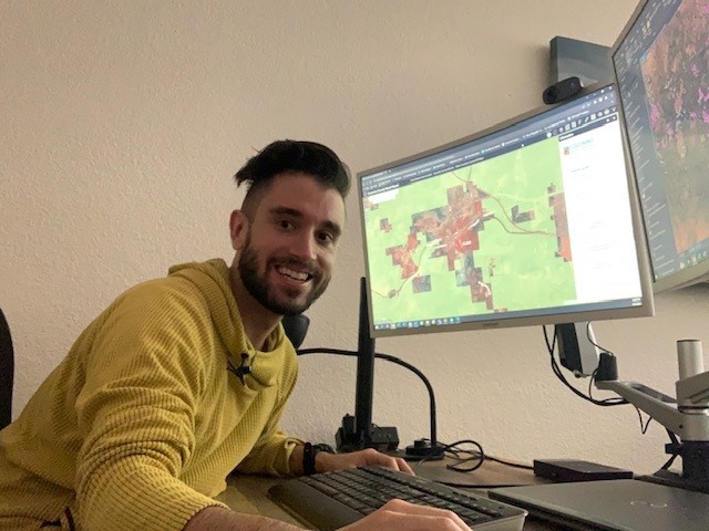
Chad McGann is employed by Coconino County as a GIS, or Geographic Information Systems, specialist. He works with the County in using data for transportation, land use, addressing, parcels and property, and roads and streets. He also uses GIS data with the County to prepare for emergency response. If someone calls 911, the information needs to be accurate so that emergency services can reach the right house, especially the correct driveway.
An exciting program in the GIS department is the creation of new subdivisions and developments. GIS can create maps and provide an actual location on the earth’s surface. From there, Chad McGann and other members of the GIS team can create streets, addresses, and parcels on a map.
”“It’s just like tracing,” McGann said. “It can be a lot of fun to see the map take shape.”
There is a lot of attention on GIS today, as businesses, government agencies, and organizations use it regularly. The technology has been improving over the years, as well, with new and more sophisticated software and updates. Coconino County GIS uses platforms like ESRI (Environmental Systems Research Institute), ArcMap, and ArcPro. Technology allows for highly accurate mapping tools.
In Coconino County, there is a small GIS team that handles considerable data. Coconino County is a large area, twice the size of Vermont, and maps are essential to County projects. The three-person GIS team handles cartography for all Coconino County projects. They recently created a map for Public Works, in a project with the Purina Plant, which is looking for storage property. They also create maps for the Sheriff’s Office and Corrections, which provides information for the Pathways to Community program. This project assists released people with reintegration support systems and locations, so that they can find services. GIS is also important to elections maps, districting, and voting precincts.
”“It is a mixture of art and science, working together,” McGann explained.
STEAM has been an important subject when discussing sciences for some time, as arts are often essential to scientific work. In the case of GIS, mapping requires visual arts, creativity, and design elements, in order to communicate the data.
It has never been easier to learn more about GIS. A quick YouTube search can provide tutorials and informational videos on GIS, and opensource platforms for citizen scientists are additional useful tools. QGIS and Google Earth are free GIS platforms that allow people to familiarize themselves with GIS concepts, play with the tools, and get a start on the program. There are also local and online classes that can help people become more familiar with GIS.
McGann stated, “People love mapping, but it can be difficult to get into.”
McGann himself discovered his interest into GIS by accident. When going to school for archeology, he took a course and fell in love with GIS. “If you are somebody who loves history and geography, this could be the career for you,” he explained. It requires curiosity, and interest in other places and landscapes, a creative mind, and attention to detail. With these skills and interests, one may find that GIS is a new favorite skill or even career path.
When not working for Coconino County, McGann loves being outside, running, hiking, and backpacking. Even when off the clock, he finds ways to include mapping, using a GPS watch to map his adventures. His love of maps is also reflected in his enjoyment for boardgames, like Settlers of Catan. He also loves Coconino County. Having lived in places as diverse as Vermont, North Carolina, and North Dakota, he appreciates the diversity and beauty of Coconino County. “It’s so wild and beautiful here,” he said. “You have the city, but in five minutes you can be out on a trail. You have the Peaks, including Mt. Humphreys, the highest point in Arizona, all the way to the bottom of the Grand Canyon. The geography here is astounding!”


 Board member, Adam Marsh, and lead paleontologist at Petrified National Forest, works with a team of scientists to uncover an approximately 300 million-year-old fossil skeleton discovered at Canyonlands National Park in Utah (June 2024)
  Board member, Kathy Farretta, joins the Arizona Historical Society as the Pioneer Museum’s new Museum Manager, a position that was vacant for nearly five years. (December 2025)